


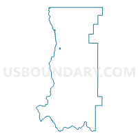
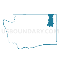
Kettle Falls 1 Voting District, Stevens County, Washington
About
Outline

Summary
| Unique Area Identifier | 689568 |
| Name | Kettle Falls 1 Voting District |
| County | Stevens County |
| State | Washington |
| Area (square miles) | 0.40 |
| Land Area (square miles) | 0.40 |
| Water Area (square miles) | 0.00 |
| % of Land Area | 99.73 |
| % of Water Area | 0.27 |
| Latitude of the Internal Point | 48.60112580 |
| Longtitude of the Internal Point | -118.05662960 |
Maps

Graphs
Select a template below for downloading or customizing gragh for Kettle Falls 1 Voting District, Stevens County, Washington


Neighbors
Neighoring Voting District (by Name) Neighboring Voting District on the Map
- Kettle Falls 2 Voting District, Stevens County, WA
- Meyers Falls 2 Voting District, Stevens County, WA